×
Close
Login
Home
SCI Abstract
Library D
Community
Events
Events & Partner
WeMed
Media Partners
Educational Partner
User Tools
FAQ/USER GUIDE
Language
English
中文/ Chinese
Contact Us
×
Close
mdla_1
mdla_2
mdla_3
mdla_4
mdla_5
mdla_6
Categories
Public, Environmental & Occupational Health
25587
Global Medical University
4747
Allergy
1660
Anatomy & Morphology
1532
Andrology
379
Anesthesia & Intensive Care
1178
Anesthesiology
5041
Audiology & Speech-Language Pathology
318
Behavioral Sciences
104
Biochemical Research Methods
6607
Biochemistry & Molecular Biology
28023
Biodiversity Conservation
289
Biology
7887
Biophysics
7492
Biotechnology & Applied Microbiology
7880
Cardiac & Cardiovascular Systems
29190
Cardiovascular & Respiratory Systems
1315
Cell & Tissue Engineering
649
Cell Biology
10698
Chemistry, Analytical
4097
Chemistry, Applied
10185
Chemistry, Medicinal
8284
Chemistry, Multidisciplinary
17738
Clinical Immunology & Infectious Disease
364
Clinical Medicine
8621
Clinical Neurology
15448
Clinical Psychology & Psychiatry
1143
Critical Care Medicine
2898
Dentistry, Oral Surgery & Medicine
12581
Dermatology
7196
Developmental Biology
6610
Ecology
632
Education, Scientific Disciplines
1891
Emergency Medicine
3743
Endocrinology, Metabolism & Nutrition
22417
Engineering, Biomedical
3529
Entomology
432
Environmental Medicine & Public Health
4403
Evolutionary Biology
247
Gastroenterology & Hepatology
11177
General & Internal Medicine
6479
Genetics & Heredity
13999
Geriatrics & Gerontology
4656
Gerontology
344
Health Care Sciences & Services
15014
Health Policy & Services
617
Hematology
5281
Immunology
23206
Infectious Diseases
13084
Integrative & Complementary Medicine
2727
Medical Ethics
1146
Medical Informatics
2088
Medical Laboratory Technology
419
Medicine, General & Internal
42178
Medicine, Legal
466
Medicine, Research & Experimental
16573
Microbiology
21777
Mycology
0
Nanoscience & Nanotechnology
4921
Neuroimaging
1237
Neurology
4179
Neurosciences
36950
Nursing
8974
Nutrition & Dietetics
7510
Obstetrics & Gynecology
7716
Oncology
49049
Ophthalmology
8954
Optics
3946
Orthopedics
10904
Orthopedics, Rehabilitation & Sports Medicine
1636
Otolaryngology
1478
Otorhinolaryngology
4592
Parasitology
1022
Pathology
4698
Pediatrics
19929
Peripheral Vascular Disease
4382
Pharmacology & Pharmacy
32709
Pharmacology/Toxicology
11348
Physiology
8306
Polymer Science
502
Primary Health Care
780
Psychiatry
17615
Psychology
4897
Psychology, Applied
86
Psychology, Biological
327
Psychology, Clinical
732
Psychology, Developmental
234
Psychology, Educational
137
Psychology, Experimental
141
Psychology, Mathematical
0
Psychology, Multidisciplinary
1572
Psychology, Psychoanalysis
30
Psychology, Social
112
Public Health & Health Care Science
2098
Quantum Science & Technology
0
Radiology, Nuclear Medicine & Imaging
11571
Radiology, Nuclear Medicine & Medical Imaging
7609
Rehabilitation
2849
Remote Sensing
0
Reproductive Biology
2559
Reproductive Medicine
1144
Research/Laboratory Medicine & Medical Technology
3696
Respiratory System
6838
Rheumatology
5466
Social Sciences, Biomedical
1124
Substance Abuse
2605
Surgery
31208
Toxicology
4129
Transplantation
939
Tropical Medicine
272
Urology & Nephrology
11913
Veterinary Sciences
35
Virology
2373
Zoology
0
Channels
INTERNATIONAL JOURNAL OF HEALTH GEOGRAPHICS
82
Journal of Public Health Management & Practice
18
Medrxiv - Public and Global Health
2327
CANCER EPIDEMIOLOGY BIOMARKERS & PREVENTION
157
EPIDEMIOLOGY
278
EUROPEAN JOURNAL OF EPIDEMIOLOGY
280
HEALTH & PLACE
437
JOURNAL OF ADOLESCENT HEALTH
43
JOURNAL OF CLINICAL EPIDEMIOLOGY
28
LANCET GLOBAL HEALTH
1
PREVENTIVE MEDICINE
325
SOCIAL SCIENCE & MEDICINE
0
AMERICAN JOURNAL OF INDUSTRIAL MEDICINE
54
ANNALS OF EPIDEMIOLOGY
396
ARCHIVES OF PUBLIC HEALTH
538
ASIA-PACIFIC JOURNAL OF PUBLIC HEALTH
103
AUSTRALIAN AND NEW ZEALAND JOURNAL OF PUBLIC HEALTH
84
COMMUNITY DENTISTRY AND ORAL EPIDEMIOLOGY
75
FRONTIERS IN PUBLIC HEALTH
7168
GEOHEALTH
53
GLOBAL HEALTH-SCIENCE AND PRACTICE
273
GLOBALIZATION AND HEALTH
275
HEALTH EXPECTATIONS
147
HEALTH POLICY AND PLANNING
0
HEALTH REPORTS
82
INJURY PREVENTION
243
INTERNATIONAL EMERGENCY NURSING
276
INTERNATIONAL JOURNAL OF ENVIRONMENTAL RESEARCH AND PUBLIC HEALTH
5740
INTERNATIONAL JOURNAL OF HEALTH POLICY AND MANAGEMENT
269
JOURNAL OF HEALTH POPULATION AND NUTRITION
213
JOURNAL OF MEDICAL SCREENING
28
JOURNAL OF MIDWIFERY & WOMENS HEALTH
81
JOURNAL OF NEUROSCIENCE NURSING
58
JOURNAL OF OCCUPATIONAL AND ENVIRONMENTAL MEDICINE
86
JOURNAL OF OCCUPATIONAL HEALTH
70
JOURNAL OF OCCUPATIONAL MEDICINE AND TOXICOLOGY
80
JOURNAL OF PROFESSIONAL NURSING
377
JOURNAL OF RADIOLOGICAL PROTECTION
236
JOURNAL OF RURAL HEALTH
102
JOURNAL OF SCHOOL HEALTH
83
NOISE & HEALTH
57
PUBLIC HEALTH
0
PUBLIC HEALTH GENOMICS
40
REPRODUCTIVE HEALTH
459
JOURNAL OF PUBLIC HEALTH POLICY
59
MALAWI MEDICAL JOURNAL
125
REVISTA DE SAUDE PUBLICA
0
SCANDINAVIAN JOURNAL OF PUBLIC HEALTH
100
SEXUAL HEALTH
230
WORLD MEDICAL & HEALTH POLICY
60
SPATIAL AND SPATIO-TEMPORAL EPIDEMIOLOGY
165
SAFETY
111
AMERICAN JOURNAL OF LIFESTYLE MEDICINE
49
EMERGING THEMES IN EPIDEMIOLOGY
23
ENVIRONMENTAL HEALTH INSIGHTS
30
EPIDEMIOLOGIA E SERVICOS DE SAUDE
0
GLOBAL HEALTH RESEARCH AND POLICY
136
HEALTH BEHAVIOR AND POLICY REVIEW
88
HEALTH PROMOTION PRACTICE
89
INDIAN JOURNAL OF COMMUNITY HEALTH
331
INDIAN JOURNAL OF COMMUNITY MEDICINE
80
INDIAN JOURNAL OF OCCUPATIONAL AND ENVIRONMENTAL MEDICINE
109
INDIAN JOURNAL OF PUBLIC HEALTH
137
INFECTION DISEASE & HEALTH
2
INTERNATIONAL ARCHIVES OF HEALTH SCIENCES
73
JOURNAL OF FAMILY AND COMMUNITY MEDICINE
30
JOURNAL OF MARINE MEDICAL SOCIETY
20
JOURNAL OF PUBLIC HEALTH IN AFRICA
105
JOURNAL OF PUBLIC HEALTH RESEARCH
142
JOURNAL OF PUBLIC HEALTH-HEIDELBERG
267
JOURNAL OF THE EGYPTIAN PUBLIC HEALTH ASSOCIATION
66
PUBLIC HEALTH RESEARCH & PRACTICE
63
KESMAS-NATIONAL PUBLIC HEALTH JOURNAL
149
MEDIA PENELITIAN DAN PENGEMBANGAN KESEHATAN
52
NEW SOLUTIONS-A JOURNAL OF ENVIRONMENTAL AND OCCUPATIONAL HEALTH POLICY
37
INTERNATIONAL ARCHIVES OF OCCUPATIONAL AND ENVIRONMENTAL HEALTH
339
INTERNATIONAL JOURNAL OF PUBLIC HEALTH
31
JOURNAL OF BEHAVIORAL HEALTH SERVICES & RESEARCH
145
JOURNAL OF CANCER EDUCATION
434
SCI Abstract
search
ALL
RECOMMENDED
+
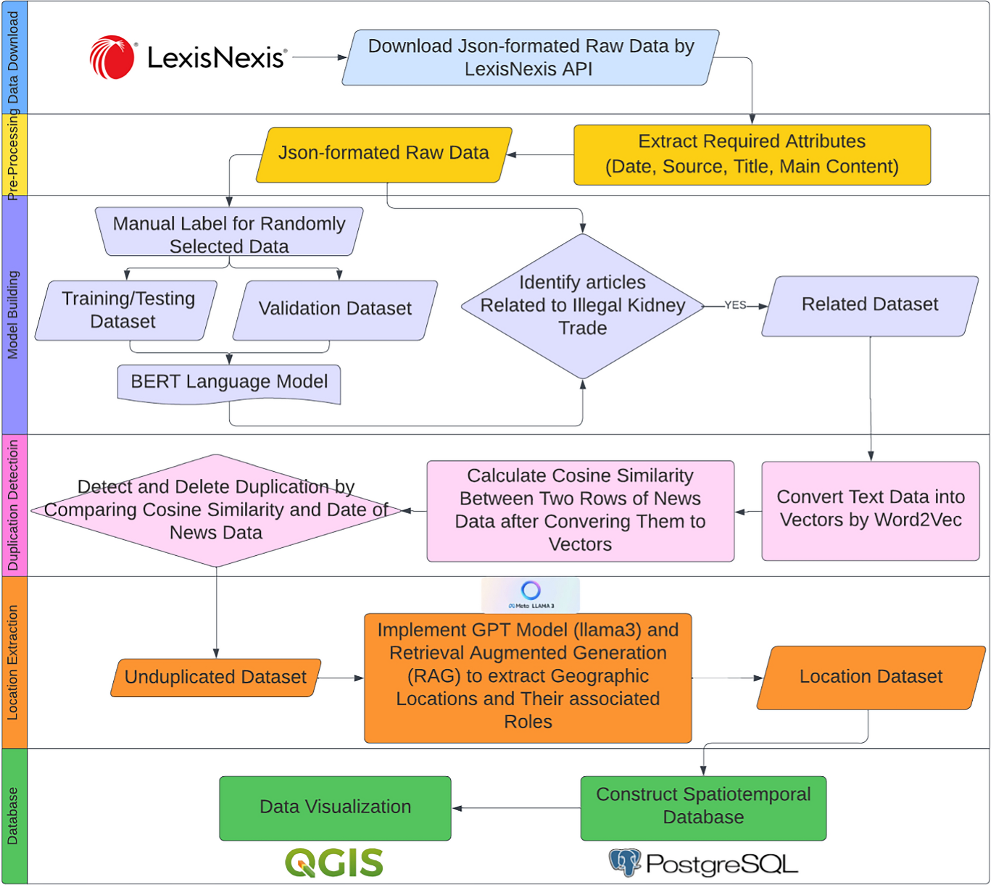
Implementing large language model and retrieval augmented generation to extract geographic locations of illicit transnational kidney trade
Illicit kidney trade networks, operating globally, involve intricate interactions among various players, most notably buye...
International Journal Of Health Geographics
comment
0
thumb_up
0
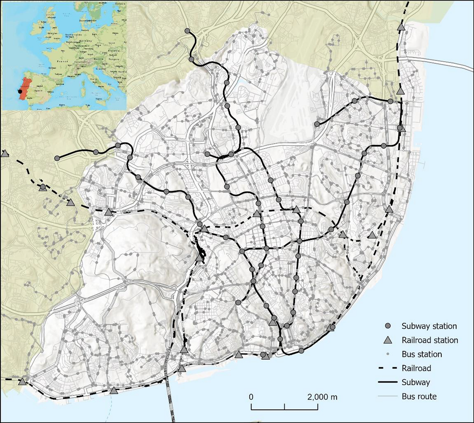
Identifying pharmacy gaps: a spatiotemporal study of multimodal accessibility throughout the day
Accessibility to community pharmacies is crucial for ensuring timely access to medications and essential health services. ...
International Journal Of Health Geographics
comment
0
thumb_up
0
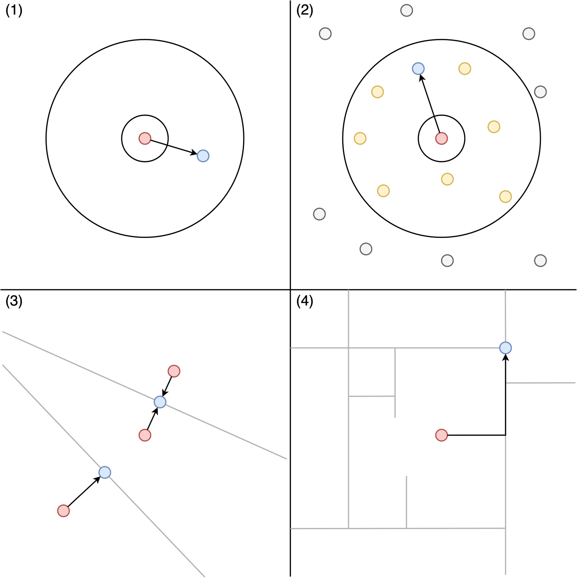
MaskMyPy: python tools for performing and analyzing geographic masks
Geographic masking is an important but under-utilized technique for protecting and disseminating sensitive geospatial heal...
International Journal Of Health Geographics
comment
0
thumb_up
0
Assessing the impact of building footprint dataset choice for health programme planning: a case study of indoor residual spraying (IRS) in Zambia
The increasing availability globally of building footprint datasets has brought new opportunities to support a geographic ...
International Journal Of Health Geographics
comment
0
thumb_up
0
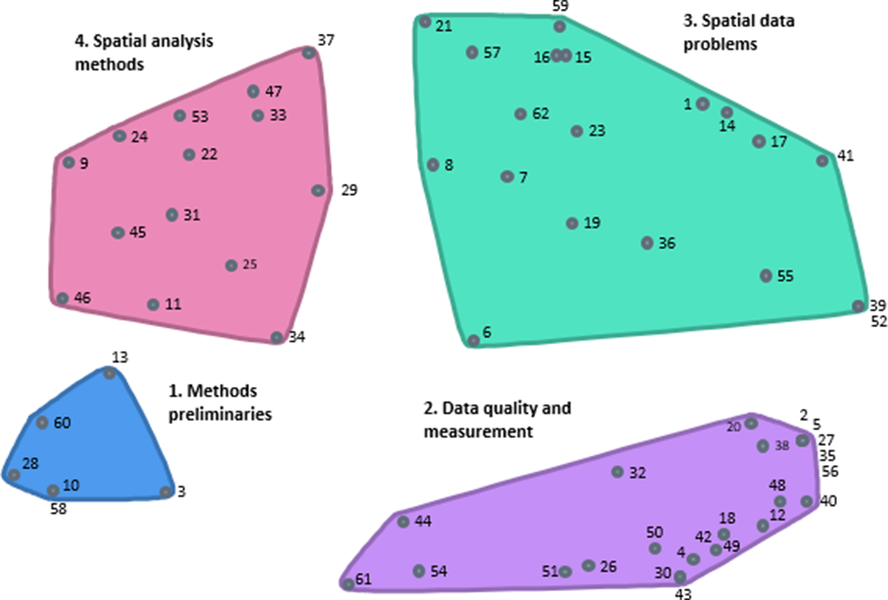
The development and validation of Spatial Methodology Appraisal of Research Tool (SMART): a concept mapping study
This study developed and validated the Spatial Methodology Appraisal of Research Tool (SMART) using group concept mapping ...
International Journal Of Health Geographics
comment
0
thumb_up
0
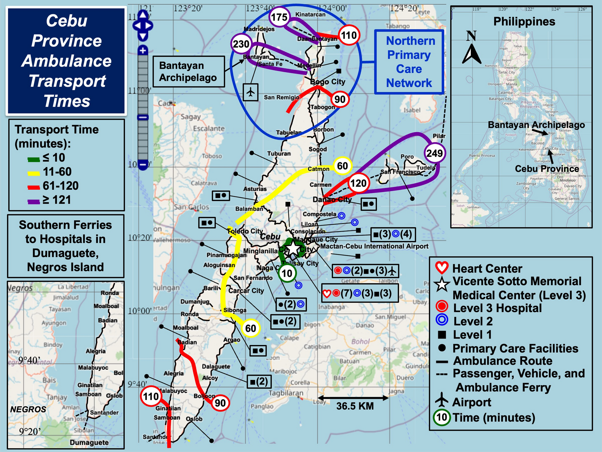
Using geographic rescue time contours, point-of-care strategies, and spatial care paths to prepare island communities for global warming, rising oceans, and weather disasters
To perform geographic contour analysis of sea and land ambulance rescue times in an archipelago subject to super typhoons;...
International Journal Of Health Geographics
comment
0
thumb_up
0
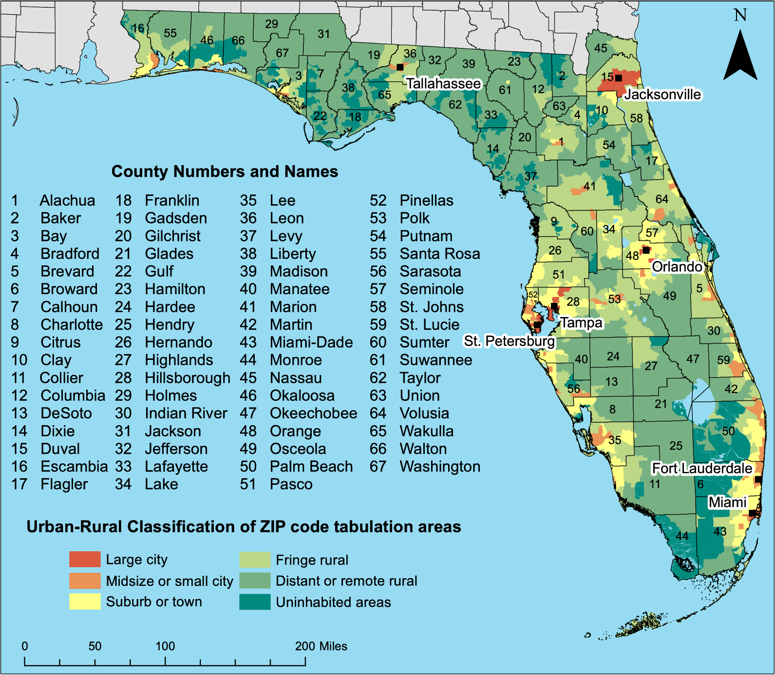
Determinants of disparities of diabetes-related hospitalization rates in Florida: a retrospective ecological study using a multiscale geographically weighted regression approach
Early diagnosis, control of blood glucose levels and cardiovascular risk factors, and regular screening are essential to p...
International Journal Of Health Geographics
comment
0
thumb_up
0
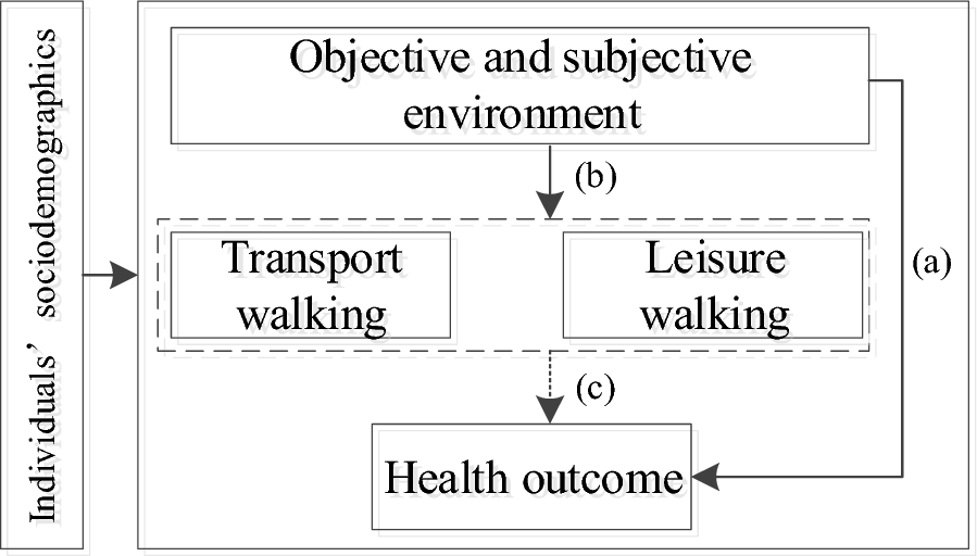
The built environment, purpose-specific walking behaviour and overweight: evidence from Wuhan metropolis in central China
The impact of objective and subjective environmental factors on health outcomes has been a topic of significant debate, wi...
International Journal Of Health Geographics
comment
0
thumb_up
0
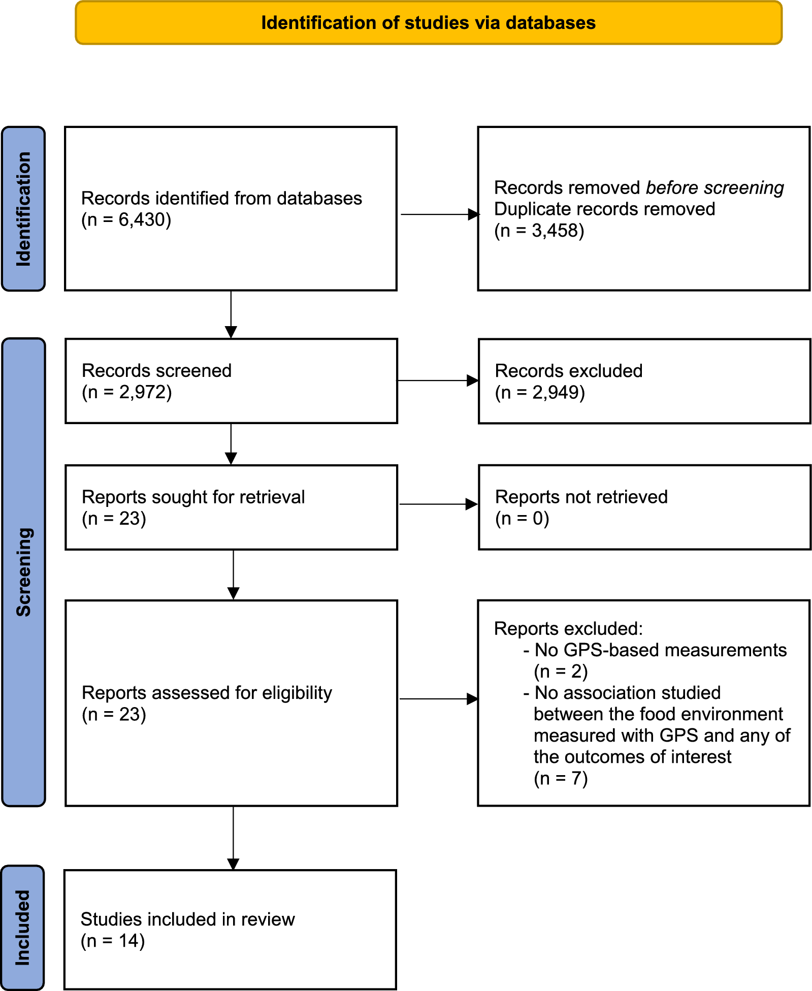
Global positioning system-based food environment exposures, diet-related, and cardiometabolic health outcomes: a systematic review and research agenda
Geographic access to food may affect dietary choices and health outcomes, but the strength and direction of associations m...
International Journal Of Health Geographics
comment
0
thumb_up
0
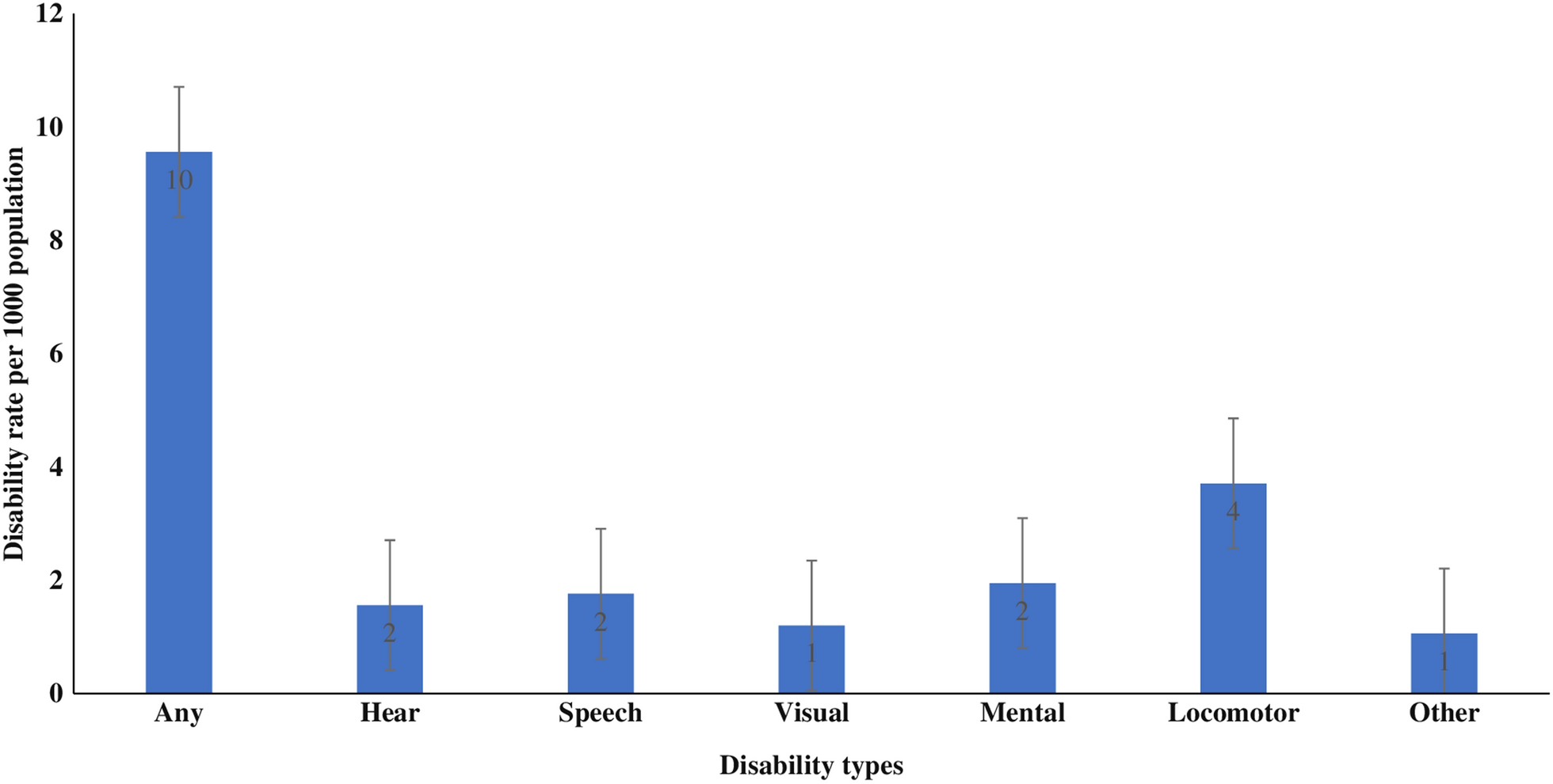
Socioeconomic and geographic variations of disabilities in India: evidence from the National Family Health Survey, 2019–21
Increasing disability is of global and national concern. Lack of evidence on disability across socioeconomic groups and ge...
International Journal Of Health Geographics
comment
0
thumb_up
0
People’s political views, perceived social norms, and individualism shape their privacy concerns for and acceptance of pandemic control measures that use individual-level georeferenced data
As the COVID-19 pandemic became a major global health crisis, many COVID-19 control measures that use individual-level geo...
International Journal Of Health Geographics
comment
0
thumb_up
0
Gravity models for potential spatial healthcare access measurement: a systematic methodological review
Quantifying spatial access to care—the interplay of accessibility and availability—is vital for healthcare pla...
International Journal Of Health Geographics
comment
0
thumb_up
0
Epidemiology, risk areas and macro determinants of gastric cancer: a study based on geospatial analysis
Both incidence and mortality of gastric cancer in Gansu rank first in china, this study aimed to describe the recent preva...
International Journal Of Health Geographics
comment
0
thumb_up
0
Revealing associations between spatial time series trends of COVID-19 incidence and human mobility: an analysis of bidirectionality and spatiotemporal heterogeneity
Using human mobility as a proxy for social interaction, previous studies revealed bidirectional associations between COVID...
International Journal Of Health Geographics
comment
0
thumb_up
0
A Bayesian maximum entropy model for predicting tsetse ecological distributions
African trypanosomiasis is a tsetse-borne parasitic infection that affects humans, wildlife, and domesticated animals. Tse...
International Journal Of Health Geographics
comment
0
thumb_up
0
Global mosquito observations dashboard (GMOD): creating a user-friendly web interface fueled by citizen science to monitor invasive and vector mosquitoes
Mosquitoes and the diseases they transmit pose a significant public health threat worldwide, causing more fatalities than ...
International Journal Of Health Geographics
comment
0
thumb_up
0
Optimizing the maximum reported cluster size for the multinomial-based spatial scan statistic
Correctly identifying spatial disease cluster is a fundamental concern in public health and epidemiology. The spatial scan...
International Journal Of Health Geographics
comment
0
thumb_up
0
Effects of greenery at different heights in neighbourhood streetscapes on leisure walking: a cross-sectional study using machine learning of streetscape images in Sendai City, Japan
It has been pointed out that eye-level greenery streetscape promotes leisure walking which is known to be a health -positi...
International Journal Of Health Geographics
comment
0
thumb_up
0
Short-term exposure sequences and anxiety symptoms: a time series clustering of smartphone-based mobility trajectories
Short-term environmental exposures, including green space, air pollution, and noise, have been suggested to affect health....
International Journal Of Health Geographics
comment
0
thumb_up
0
Physical environment features that predict outdoor active play can be measured using Google Street View images
Childrens’ outdoor active play is an important part of their development. Play behaviour can be predicted by a varie...
International Journal Of Health Geographics
comment
0
thumb_up
0
Capturing emergency dispatch address points as geocoding candidates to quantify delimited confidence in residential geolocation
In response to citizens’ concerns about elevated cancer incidence in their locales, US CDC proposed publishing cance...
International Journal Of Health Geographics
comment
0
thumb_up
0
Assessing the association between food environment and dietary inflammation by community type: a cross-sectional REGARDS study
Communities in the United States (US) exist on a continuum of urbanicity, which may inform how individuals interact with t...
International Journal Of Health Geographics
comment
0
thumb_up
0
Small-area estimation and analysis of HIV/AIDS indicators for precise geographical targeting of health interventions in Nigeria. a spatial microsimulation approach
Precise geographical targeting is well recognised as an indispensable intervention strategy for achieving many Sustainable...
International Journal Of Health Geographics
comment
0
thumb_up
0
Empowering health geography research with location-based social media data: innovative food word expansion and energy density prediction via word embedding and machine learning
The exponential growth of location-based social media (LBSM) data has ushered in novel prospects for investigating the urb...
International Journal Of Health Geographics
comment
0
thumb_up
0
Recreational walking and perceived environmental qualities: a national map-based survey in Denmark
The aim of the study is to explore the diversity in recreational walking motives across groups with different sociodemogra...
International Journal Of Health Geographics
comment
0
thumb_up
0
Spatial and temporal trends of overweight/obesity and tobacco use in East Africa: subnational insights into cardiovascular disease risk factors
Cardiovascular disease (CVD) is increasing in Sub-Saharan Africa (SSA). Overweight/obesity and tobacco use are modifiable ...
International Journal Of Health Geographics
comment
0
thumb_up
0
Small area analysis methods in an area of limited mapping: exploratory geospatial analysis of firearm injuries in Port-au-Prince, Haiti
The city of Port-au-Prince, Haiti, is experiencing an epidemic of firearm injuries which has resulted in high burdens of m...
International Journal Of Health Geographics
comment
0
thumb_up
0
Socioeconomic and environmental determinants of asthma prevalence: a cross-sectional study at the U.S. County level using geographically weighted random forests
Some studies have established associations between the prevalence of new-onset asthma and asthma exacerbation and socioeco...
International Journal Of Health Geographics
comment
0
thumb_up
0
Impacts of seasonal flooding on geographical access to maternal healthcare in the Barotse Floodplain, Zambia
Seasonal floods pose a commonly-recognised barrier to women’s access to maternal services, resulting in increased mo...
International Journal Of Health Geographics
comment
0
thumb_up
0
Association of neighborhood physical activity facilities with incident cardiovascular disease
The availability of physical activity (PA) facilities in neighborhoods is hypothesized to influence cardiovascular disease...
International Journal Of Health Geographics
comment
0
thumb_up
0
Load More
Modal title
×
Modal title
×
Share
Login
Global News and Health Forum
Join Now!
Member Login
Remember me
Forgot password?
Or using
Linkedin