School Data
Public school data were collected from the National Center for Education Statistics (NCES) Education Demographic and Geographic Estimates (EDGE) program [25]. We collected locations of all public schools as latitude and longitude reported through the Common Core of Data (CCD) program, and school catchment areas as polygon shapefiles through the School Area Boundary Survey (SABS) program. School catchment areas are the geographic areas in which resident children are assigned to attend a specific school and represent neighborhoods in this project. The most recent SABS data are from school year 2015–2016; we assume temporal stability in catchment areas. We collected public school demographics from the CCD using the Elementary/Secondary Information System (ElSi) data tool for school year 2020–2021 [26]. For each school, we collected the grade levels served, total students, and race/ethnicity of students. Schools were classified as elementary schools if they had students in grade 5 or below, as middle schools if they had students in grades 6, 7, or 8, and as high schools if they had students in grades 9 through 12. This resulted in some areas having multiple schools of the same classification and some schools having multiple classifications. For example, a school where students went to the same school from kindergarten through sixth grade would be classified as both an elementary and a middle school, and if that area had a different school for seventh and eighth graders, both the school with sixth graders and the school with seventh and eighth graders were classified as middle schools. We operationalized school demographics as the proportion of students that were Black, Hispanic, or White out of the total number of students that reported race/ethnicity.
Our analytic sample of schools (n = 54,780) excludes schools that failed to report to either the CCD or EDGE programs (n = unknown), schools identified as “open enrollment” which draw their student body from a broader geographic area than traditional neighborhood schools (n = 4,415), and schools not located in a metropolitan or micropolitan area (n = 8419).
Neighborhood Data
Neighborhood data were collected from the American Community Survey 5-year estimates 2017–2021 at the block group level (census tract for poverty) [27]. Collected variables were total population, Hispanic origin by race for all ages, poverty status in the past 12 months by age, median household income, and median home value. Census areas were assigned to school catchment areas based on centroid location.
Land Surface Temperature
The average September afternoon land surface temperature (LST) at each school was identified by averaging the four 8-day Land Surface Temperature L3 1 km Aqua products covering the month of September each year for 2019–2022. We chose to use Aqua data because the northward pass of the Aqua satellite over the continental US occurs in the midafternoon, although it does not necessarily coincide with the hottest temperature of day. We chose to focus on September because while there is variability in the academic calendar, most schools are in session in September. School LST was defined as the average of the pixel in which the school coordinate was located and all eight neighboring cells. LST is not the same as air temperature, but the two measures are highly correlated [28, 29]; LST is used frequently in urban heat studies [9,10,11]. Google Earth Engine was used for satellite image processing.
Local Region
We defined the local region to be the metro- or micropolitan statistical area (MSA) in which the school is located. MSAs are US Census-defined areas representing core urban areas and associated areas with interrelated social and economic networks [30]. Including the local region as a fixed effect in the analysis controls for sociodemographic residence patterns that correspond with climate (e.g., greater Hispanic populations are found in the Southwest, where it is generally hotter than other parts of the US) and ensures that identified effects represent deviations from regionally expected September afternoon mean temperatures. Additionally, MSAs are geographic levels that represent policy-relevant units for addressing disparities.
Analysis
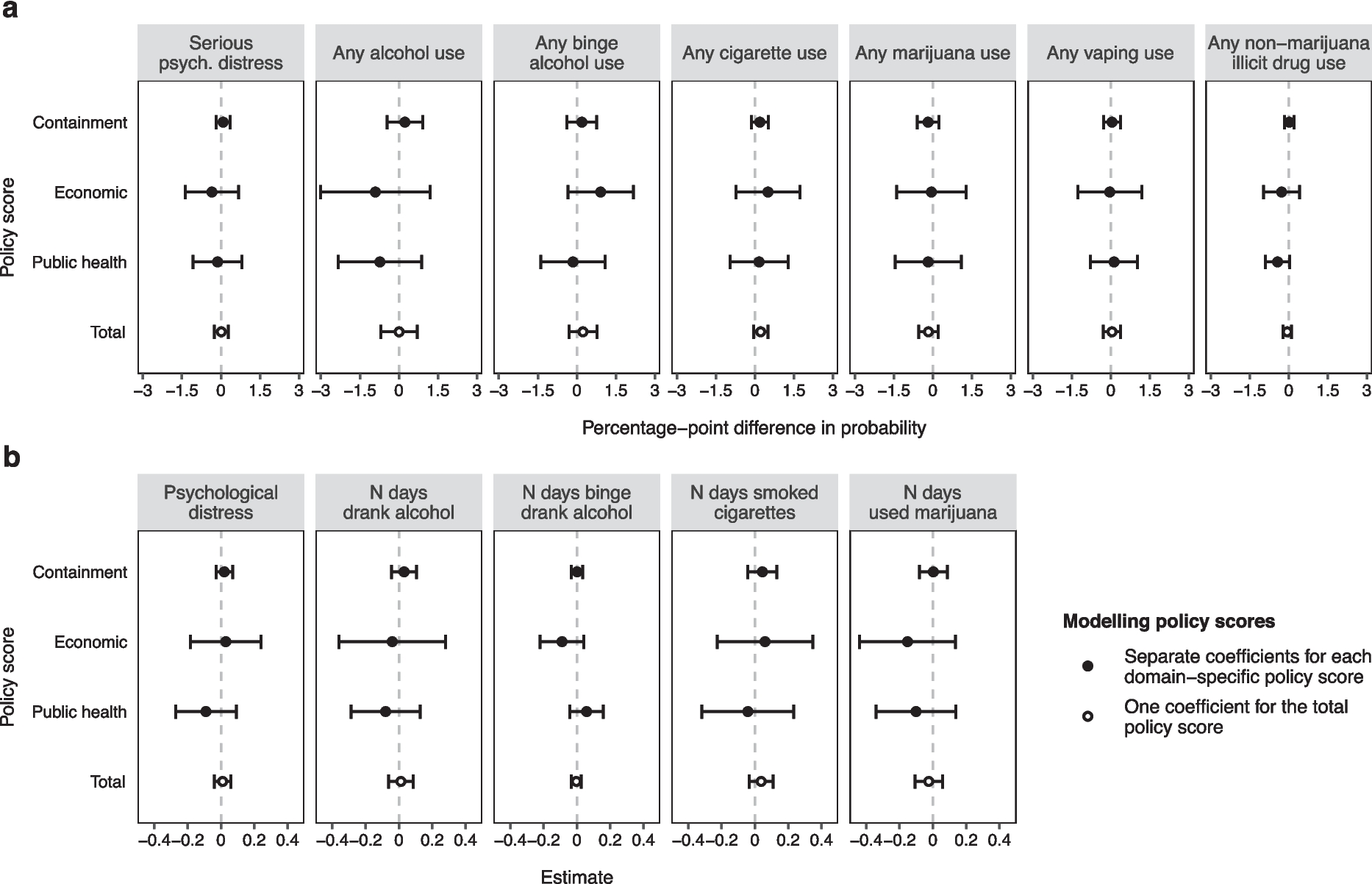
Summary statistics describe the sample. We estimated separate ordinary linear regression models to identify associations between school demographics and September afternoon school LST, controlling for neighborhood sociodemographics and including a fixed effect for MSA area. We created school demographic residual variables because school demographics depend on and are correlated with neighborhood demographics (correlations between 0.92 and 0.94). Specifically, we regressed school proportion Black, Hispanic, or White on neighborhood proportion Black, Hispanic, or White. The effect associated with the school demographic residual represents the additional additive effect of the school population deviating from the neighborhood population, beyond the neighborhood effect. This effect will be non-zero and significant if there is a separate association between LST and the school population in addition to the neighborhood effect. Elementary, middle, and high schools were modeled separately.
To understand the impact of disparate school temperature conditions on children, we classed schools by heat quintiles within the local region (e.g., quintiles defined within each MSA, regardless of quintile cutoff values across MSAs). We summed student counts within quintiles and present data on the demographics within and across heat quintiles.
Sensitivity Analyses
We tested for sensitivity to the definition of local region, neighborhood socioeconomic status, and home neighborhood. We alternately defined local region as the state and as 5-, 10-, and 25-mile buffers around the school. We alternately defined neighborhood socioeconomic status as the median household income in the catchment and the median home value in the catchment. We alternately defined home neighborhood as the census block groups closer to focal school than any other (e.g., the Voronoi neighborhood).
We tested for sensitivity associated with any geographic change in school locations and catchment boundaries between the 2015 and 2016 school year (the latest year for which NCES EDGE data was available) and the more recent census and temperature data that we used in the analyses. We did this by collecting ACS data for the 5-year estimates spanning 2012–2016 and LST data for the years 2013–2016 and repeating all analyses.
Because weather may differ depending on region, we also tested relationships separately by region. We tested each of nine US climate regions as defined by the National Centers for Environmental Information, as follows: West (California and Nevada), Northwest (Idaho, Oregon, and Washington), Southwest (Arizona, Colorado, New Mexico, and Utah), Northern Rockies and Plains (Montana, Nebraska, North Dakota, South Dakota, and Wyoming), West (Arkansas, Kansas, Louisiana, Mississippi, Oklahoma, and Texas), Upper Midwest (Iowa, Michigan, Minnesota, and Wisconsin), Ohio Valley (Illinois, Indiana, Kentucky, Missouri, Ohio, Tennessee, and West Virginia), Southeast (Alabama, Florida, Georgia, North Carolina, South Carolina, and Virginia), and Northeast (Connecticut, Delaware, Maine, Maryland, Massachusetts, New Hampshire, New Jersey, New York, Pennsylvania, Rhode Island, and Vermont) [31].


Comments (0)